Classroom & live online 200 Hours Verifiable certificate Syllabus ↓

Land Survey Course

200-hour land survey course: levelling, theodolite, total station, GPS/DGPS and survey plotting in AutoCAD.

Your roadmap — from admission to certificate

  1. Free counselling

    Talk to our counsellor — choose the right course, batch time and mode.

  2. Admission

    Join at a CADD centre near you or online. You get your student login and ID card.

  3. Learn step by step

    200 Hours of hands-on Land Survey classes — in the classroom or live online.

    Session 1: Surveying Fundamentals (Theory)Session 1: Surveying Fundamentals (Practical)Session 2: TheorySession 3: TheorySession 2: PracticalSession 3: PracticalSession 4: TheorySession 4: PracticalSession 5: TheorySession 5: Practical
  4. Practice & project

    Exercises in every class and a final project, checked by your trainer.

  5. Course completion certificate + completion badge

    Finish the course and get your course-completion certificate and a digital completion badge with your name.
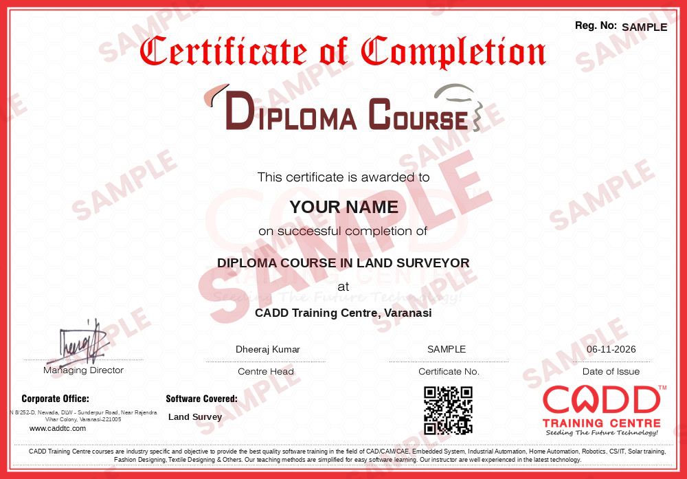
    Sample course-completion certificate — DIPLOMA COURSE IN LAND SURVEYOR
    Course-completion certificate (sample) — DIPLOMA COURSE IN LAND SURVEYOR · verifiable online
    Course-completion badge — DIPLOMA COURSE IN LAND SURVEYOR
    Course-completion badge
    Course
    DIPLOMA COURSE IN LAND SURVEYOR
    Issued by
    CADD Training Cetre
    Training
    Classroom or live online
    How to earn
    Complete the course and its project
    With your name and year · its own verify link · “Add to profile” on LinkedIn
  6. Certification exam

    Take the certification exam: a theory test and a practical task — at the centre or online.

  7. Certified certificate + marksheet

    Pass the exam and get the certified certificate with your marksheet. Anyone can check it online with its QR code.

  8. Certified badge

    Your certified badge — add it to LinkedIn and share it anywhere; it opens its own verify page.
    Certified badge — DIPLOMA COURSE IN LAND SURVEYOR
    Certified badge
    Course
    DIPLOMA COURSE IN LAND SURVEYOR
    Issued by
    CADD Training Cetre
    Training
    Classroom or live online
    How to earn
    Pass the certification exam
    You also get
    Certified certificate + marksheet
    With your name and year · its own verify link · “Add to profile” on LinkedIn
  9. Make your CV & apply for jobs

    Make your CV in your student panel (Career → My CV) — your course, certificates and projects are added for you. Send it as a link with a preview picture, and apply to jobs and Hire Me requests from companies.

About the Land Survey course

Land surveying is the measurement and mapping of land, buildings and sites so that roads, buildings, plots and utilities can be planned and set out correctly. Surveyors work with contractors, survey agencies, land and revenue departments and construction companies, using instruments that range from tapes and auto levels to total stations and GPS/DGPS receivers.

This 200-hour Land Survey course combines theory, instrument handling, field exercises and computer plotting. You begin with chain, tape and compass surveys and field book recording, then learn levelling with an auto level and reduced level calculation, angle measurement and traversing with a theodolite, and total station set-up, observation and data download. GPS and DGPS work introduces coordinate systems and accurate position collection. You also calculate areas and volumes, plot contour maps and prepare survey drawings and layout plans in AutoCAD. Calculations and plotting can be followed in live online classes, while instrument practice takes place in the classroom and field at CADD centres.

The course prepares civil students, diploma and ITI holders and field assistants for roles such as land surveyor, survey assistant, total station operator, GPS survey technician and site layout surveyor. Learners who want stronger drafting skills for survey plans can follow it with AutoCAD Master.

You will be able to

  • Carry out chain, tape and compass surveys and record field books
  • Run levelling with an auto level and calculate reduced levels
  • Measure angles with a theodolite and run a traverse
  • Set up a total station, record observations and download data
  • Collect coordinates with GPS/DGPS and understand coordinate systems
  • Calculate areas and volumes and plot contour maps
  • Prepare survey drawings and layout plans in AutoCAD

Who it is for

  • Civil engineering students and diploma holders
  • ITI surveyor trainees and field assistants
  • Job seekers aiming for surveyor or survey assistant roles
  • Land, revenue and construction staff who handle measurements

What you need

  • Basic mathematics, including geometry and trigonometry
  • Ability to do outdoor field work
  • A Windows PC with AutoCAD for plotting work in live online classes

Courses that include Land Survey

DIPLOMA COURSE IN LAND SURVEYORDiploma Course · 200 Hours
Enquire →
GIS & Mapping Technician – Associate Career ProgramAssociate Career Program · 250 Hours · 3 software
Enquire →
Land Surveyor (CAD) – Associate Career ProgramAssociate Career Program · 290 Hours · 3 software
Enquire →
GIS Analyst – Associate Career ProgramAssociate Career Program · 370 Hours · 4 software
Enquire →
Land Surveyor (CAD) – Professional Career ProgramProfessional Career Program · 394 Hours · 5 software
Enquire →
GIS Analyst – Professional Career ProgramProfessional Career Program · 490 Hours · 6 software
Enquire →
GIS & Mapping Technician – Professional Career ProgramProfessional Career Program · 474 Hours · 7 software
Enquire →

Land Survey Syllabus

14 chapters · 10 topics
01 Session 1: Surveying Fundamentals (Theory) 6 topics
  1. Introduction About Surveying
  2. History of Survey
  3. Role of Land Surveyors
  4. Understanding the Instruments Handling
  5. Safety Precautions
  6. Understanding the Scaling Concept & It's Types
02 Session 1: Surveying Fundamentals (Practical) 4 topics
  1. How to Handle and Use of Surveying Instrument's
  2. Safety Rules During the Surveying
  3. Measurements by Using the Tape and Scale
  4. Understanding the Unit Conversion
03 Session 2: Theory 0 topics
Topics for this chapter will be added soon.
04 Session 3: Theory 0 topics
Topics for this chapter will be added soon.
05 Session 2: Practical 0 topics
Topics for this chapter will be added soon.
06 Session 3: Practical 0 topics
Topics for this chapter will be added soon.
07 Session 4: Theory 0 topics
Topics for this chapter will be added soon.
08 Session 4: Practical 0 topics
Topics for this chapter will be added soon.
09 Session 5: Theory 0 topics
Topics for this chapter will be added soon.
10 Session 5: Practical 0 topics
Topics for this chapter will be added soon.
11 Session 6: Theory 0 topics
Topics for this chapter will be added soon.
12 Session 6: Practical 0 topics
Topics for this chapter will be added soon.
13 Session 7: Theory 0 topics
Topics for this chapter will be added soon.
14 Session 7: Practical 0 topics
Topics for this chapter will be added soon.

Ratings & reviews

Students rate the course after they finish it — their ratings appear here.

Land Survey course — FAQ

What is taught in the Land Survey course?

The course covers chain and compass survey, levelling, theodolite traversing, total station work, GPS/DGPS, area and volume calculation, contouring and plotting survey drawings in AutoCAD.

Who can do a land survey course?

Civil students, diploma and ITI holders, field assistants and job seekers can join. Comfort with basic mathematics and willingness to work outdoors are important.

What is the duration of the Land Survey course?

The Land Survey course runs for 200 hours, combining theory, instrument handling, field exercises and computer plotting.

Can I learn land surveying online?

Theory, calculations and AutoCAD plotting can be done in live online classes, while instrument practice is done in the classroom and field at CADD centres.

Will I get a certificate after the survey course?

Yes. Land Survey learners receive a CADD Training Centre certificate after the 200 hours. Survey agencies and contractors can confirm it online with the QR code or verification code.

What jobs can I get after a land survey course?

The course supports roles such as land surveyor, survey assistant, total station operator, GPS survey technician and site layout surveyor with contractors and survey agencies.

What is a total station in surveying?

A total station is an electronic instrument that measures angles and distances together and stores coordinates. It is the main instrument for modern building, road and land surveys.

What is the difference between GPS and DGPS survey?

Standard GPS gives positions with metre-level accuracy. DGPS uses a base station correction to reach centimetre-level accuracy, which is needed for engineering and land surveys.

More questions? Ask our counsellor or read the general FAQ.

Land Survey200 Hours
Enquire now